


Hunting and Fishing News Blog Articles
The Western Fire Chiefs Association Introduces Phase 2 of its Wildland Fire Map
First of Its Kind to Incorporate Live Aircraft Tracking, 3D Fire Map Rendering,
and California-Specific FIRIS Real Time Fire Mapping
The Western Fire Chiefs Association (WFCA) announces the introduction of Phase 2 of its Fire Map (https://wfca.com/fire-map), which launched in July this year. Phase 2 includes 3D map views, reporting of active fire-fighting aircraft in real-time, and Fire Integrated Real-Time Intelligence System (FIRIS) specific to the state of California. These new introductions provide an even higher level of detail to keep lives, land, and property safe.
“Wildland fires are often at their most dangerous when they first start,” said Brent VanKeulen, Deputy Director, WFCA. “This information will significantly impact the speed in which we can get information out to the public, and will also provide a more detailed and richer level of visual communications to communities at
risk.”
The WFCA Fire Map is the first of its kind to integrate real-time flight mapping of fire-fighting aircraft. The Forest Service uses aircraft to track, manage, and fight wildland fires. These include aerial supervision aircraft that communicate with firefighters on the ground, air attack aircraft coordinating aerial fire fighting, air tankers with the capability to deliver up to 8,000 gallons of fire retardant, water scoopers, and smoke-jumper aircrafts. Fire Suppression Aircraft are depicted on the WFCA Fire Map, with aircraft type, speed, and altitude. Clicking on an individual aircraft reveals that aircraft’s recent flight path indicating where current fire-fighting activity is taking place.
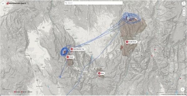 Lead Plane conducting a Fire Suppression Mission over the Double Creek & Sturgill Fires in Oregon – live feed, Sep 27, 2022 : 3:42 PM
The WFCA Fire Map is also the first to depict Wildland Fire activity in 3D, where the viewer can rotate their vantage point around the fire map and view the fire from 360 degrees.
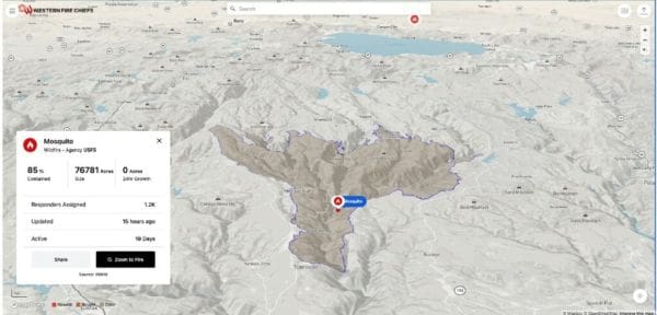 Mosquito Fire in California depicted in 3D
Specific to California, the WFCA Fire Map will integrate fire-perimeter data provided by FIRIS (Fire Integrated Real-time Intelligence System) and will be the first to do so. FIRIS is a public-private partnership that provides real-time intelligence data on emerging incidents in California. Funded by the California Office of Emergency Services, the funding supports aircraft, a common operating picture, and near-real-time fire modeling that is available at the onset of emerging incidents.
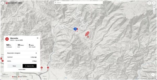 Manzanita Fire, California perimeter reported via FIRIS hours before any other fire map
“FIRIS provides real-time situational awareness for firefighters on the ground, helping them make critical decisions. I believe that the same information helps the public, too. That is why we have partnered with the WFCA,” said Brian Fennessey, founder of FIRIS, California Fire Chiefs Fire Chief of the Year, and Orange County Fire Authority Chief. FIRIS began in 2019 and uses the Overwatch Imaging platform, which includes an aerial infra-red (IR) platform that integrates cutting-edge technologies provided by Aevex Aviation. That data is fed to Intterra’s wildfire decision support software where WIFIRE retrieves the data for predictive analytics.
About the WFCA
The Western Fire Chiefs Association represents fire-related emergency service organizations throughout the west coast and Western Pacific Islands. The WFCA is dedicated to protecting people and the environment from the occurrence and outcomes of fires and other natural, technological, and human-behavior-caused emergencies. In July, the WFCA launched its Fire Map which pulls data from the US Forest Service via the National Interagency Fire Center IRWIN feed and 911 Dispatch data via PulsePoint to track the location of the wildfire as they start and while they’re burning. The WFCA Fire Map is the first map of its kind to pull such data from 911 Dispatch in relevant areas, show live fire fighting aircraft, depict wildland fire in 3D, and is the only fire map that integrates FIRIS where it is available in California.
The post The Western Fire Chiefs Association Introduces Phase 2 of its Wildland Fire Map appeared first on HuntingLife.com.
Copyright
© Hunting and Hunting Gear Reviews